Determining Ss and S1 for Seismic Loading
Revised
7/01/2014
There is a very simple but powerful aid available on
the USGS web site that will do the following:
1)
Generate Ss and S1 as a function of your
project site Latitude and Longitude coordinates.
2)
Ss and S1 may be generated for any of the
following codes: 2003-2009 NEHRP, 2005-2010 ASCE 7, 2006-2012 IBC, 2009
AASHTO.
3)
Values may be generated for the Coterminous
US states,
For engineers interested
in seismic design of buildings - currently for the U.S. and its Territories,
for imminent and current model design codes:
- A U.S.
Seismic Design Maps Web Application for, currently, seismic design
values from the 2005 ASCE 7 Standard, the 2006/2009
International Building Code, the 2003 and 2009 NEHRP Recommended Seismic Provisions, the 2009 AASHTO Guide Specifications for LRFD Seismic Bridge
Design, the 2010 ASCE 7 Standard, and the 2012 International
Building Code - i.e., for imminent/current model design codes (in
most jurisdictions).
- Two other design aids are available and
referenced near the bottom of this document.
The initial main screen appears as shown below.
Work your way down the list of required inputs to
obtain the desired Ss and S1 values.
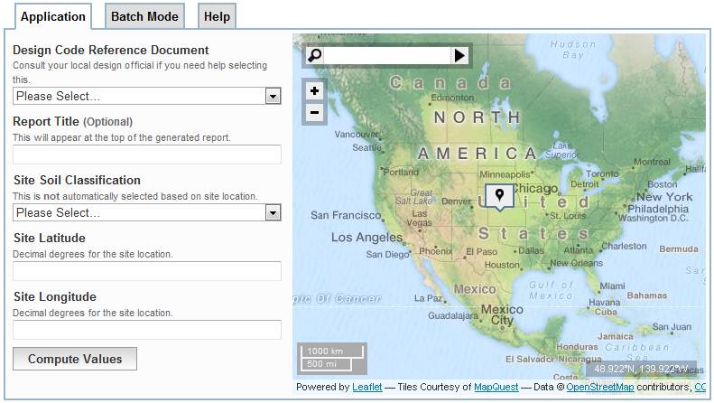
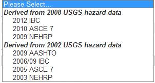
Your Design Code Reference Document must be
chosen:
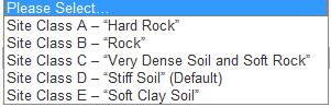
Then a Site Soil Classification needs to be
selected:
Once your Design Code has been selected, your
Risk Category area will be available for selection:

Finally, using the roller on your mouse, zoom in to
the site location of your project.
You can begin first by typing in the name of the
city and state your project is in to get to your final location quicker.
![]()
Once you get fairly close to the final location,
click on and drag the box with the ![]() in it and place it right where your new
building is to be located.
in it and place it right where your new
building is to be located.
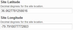
The decimal degrees will then be displayed in the
below areas.

Click on the button below to generate a report -
![]()
IF your web browser has Pop-ups blocked you will see
the below pink shaded area at the top left of your browser window.
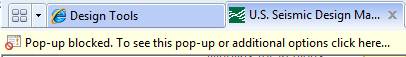
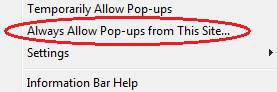
Left click on the pink shaded area and select the
below option:
You may need to click on the Compute Values
button once again and then see the below “thinking” screen before the Summary
Report is first created.
![]()
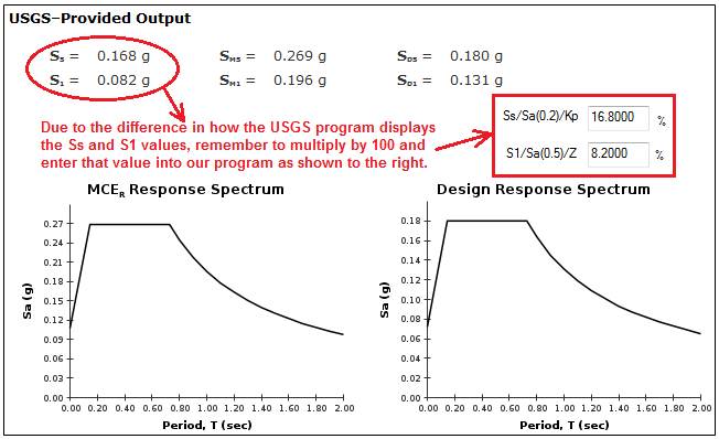
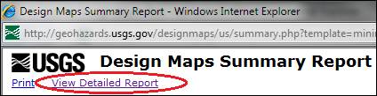
Sample output below from one of the two reports that
are available - the Summary Report.
A Detailed Report is also available by selecting the
hyperlink shown below which is at the top left of the Summary Report.
From either of the reports you prefer, then click
the Print button which you
should also see in the top left of the screen where your report is displayed.
Use this link < http://geohazards.usgs.gov/designmaps/us/help.php
> on the USGS web page for helpful information on using this web aid.
Some frequently asked questions (FAQ’s) also
can be reviewed here < http://www.usgs.gov/faq/index.php?sid=54684&lang=en&action=show&cat=144
> on the USGS web page.
There is also a third
separate tool for buildings outside of the U.S. and its Territories:
- A Worldwide
Seismic “DesignMaps” Web Application for
seismic design values needed in using the International Building Code
(§1613) and similar standards (e.g., the ASCE-7 Standard and
the U.S. Department of Defense Unified Facilities Criteria) in
other countries.
Resource Links
-
- USGS
2008 Hazard Data
- USGS
2002 Hazard Data
- USGS
1996 Hazard Data
- NEHRP Website
- ASCE
7 Standard
- AASHTO